
Saturday 2nd February 2019. An extremely challenging day’s hike in the stunning, snowy Fife countryside. 8 hours (probably 6.5 – 7 if I had not got lost) = approximately 30kms (16.5 miles).
Beware – lots of snowy tree photos ahead!
Two weeks ago I finished at Guardbridge, just outside the town of Leuchars. Today my plan was to get the bus back there from Edinburgh to resume.

There was snow last night and sleet was still pounding on my window in Edinburgh at 5.30am when the alarm went off. I was worried that I might not be able to make the journey, but I had booked my hostel and completed all the preparations, so I was determined. I did, however, change my mind and decided to take the train which is much quicker (and £2.50 more expensive). This meant I would miss the Guardbridge to Leuchars section (approximately 1 mile).

From the train I watched the sun coming up over the horizon. All the fields were white and the buildings etched with a black line. There were fields of dome-shaped greenhouses, some covered and some simply skeletons in the middle of winter.
At 8.36 I left Leuchars Station. There was a heavy, dull grey cloud cover above, but between that and the ground there were bare branches of trees showing against a delicate bird-egg-blue sky. In that space were horizontal clouds touched with peach, apricot and a darker, bruised blue. The land was glowing white, everywhere was covered in snow, although the roads were clear. Oh! the air smelled so crisp as it passed through my nostrils.
![]()
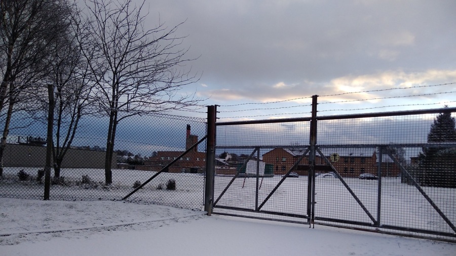
I turned left out of the train station. * Note that on Google Maps, ‘Leuchars Station’ is the Royal Air Force (RAF) Base. Make sure you look for the red train symbol if you are locating the railway station.
Although Leuchars is best known as the RAF base (which probably explains the amount of buses and the cost of the train), there must be others who live here because the out-of-breath man who ran up just as the train was pulling away had a cello with him.
I made my way past extensive barbed wire fences, cars rushing past. There was just one other man walking and he had a white Scottie dog. (I have called my Scottish blogs Walking Without A Dog because although I do not have one, it sometimes seems as if everyone else does).
I was setting off walking again and my tummy, which had been all excited for the previous two hours, turned over. My nose was sniffly from the cold. I found that I didn’t know which way to look when crossing the road, a throw back to all the hiking I have done on the continent! Here the temperature was a mere one degrees.
I was following signs to the Fife Coastal path (FCP) which took me by the road. On the right is a cluster of shops (a Spar supermarket with a butcher’s shop opposite) and a sign off to the left for it, but I recommend taking the left which goes steeply uphill for a few minutes to the beautiful Medieval church of St Athernase.


As usual it is hard to know where to find the way as you exit a town. There were clear signs for the cycle path and various ones for the FCP, but it was hard to know if they were for the cars or hikers. I headed off down School Hill / Pitlethie Road, hoping that was right. A merry hello was exchanged with two women. When I passed a slow lady with a stick afterwards which reminded me of my patients at the hospice, I felt grateful that I could walk.
As I started getting into my stride and the town started to peter out, the sun was out and the birds were singing. More and more of the sky was blue. My shadow was so long that my head was right over the other side of the road on a field looking very funny. Past Castleknowe housing estate and Pitlethie House on the left, I understood why people wear gaiters because the snow was going down the back of my heel, inbetween my boot and foot which very chilly. A blackbird was foraging in the snow.

Although I knew I was heading out of town in the right general direction and knew where the sea was, there were no official indications (a sure sign that I wasn’t right!) I was on a country road now with no pavements, but with fields on both sides and well shaved hedges in blobs – thorny and prickly with flat tops. Some of the tree trunks were going off at a very acute angles implying how strong the wind could be here. I could see the forest in the distance.
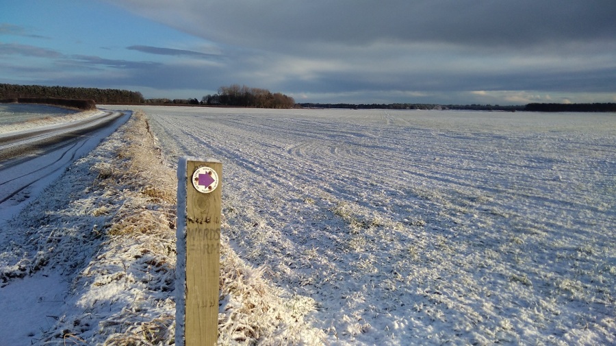
Then I turned right to cross on a path between the fields, heading towards the coast. There was incredibly bright sun on my right, making the snow sparkle, and lots of footprints and bike tracks on the snow ahead of me, even though it was only 9am.
I heard shots off to the left – hunting or soldiers practicing maybe? It was bumpy and the ground was ice hard underneath so my feet crunched.

There were engine sounds emanating from somewhere. It was deserted. A tower in the distance was topped with a slowly turning satellite; cubes of houses with pointy rooves were covered in snow; tractor tyre grooves were clear; and shadows far, far longer than the height of the trees themselves.

A helicopter came loudly into view as I turned the corner and passed between pretty Scots pines and snow-covered gorse. I took my gloves off. Yellow flowers showed through where the sun had exposed them; and the silverbirch trunks matched the fields behind.
I needed a pee, but was sure I would be seen by surveillance given the nearness of the Base. When it became imperative, I imagined the soldiers having a laugh at the sight of me on camera. I left no trace.
Chaffinches sat on hawthorn bushes, tweeting and then swooping from top of bush to top of bush just ahead of me. There were sparrows too, and beehives on my left in a little clearing. The tree trunks were are all intertwining and covered in yellow lichen, positively glowing, one with its seedpods drooping and shiny.
My attention was attracted to the barbed wire strip at the top of the fence where each of the barbs had little piles of snow on them, softening the sharpness and making them look like embroidery, like a row of stitching with cotton knots at regular intervals.
Shush shush as I walked, a crunch at the end of each step as my toe pushed down into the packed snow. There was a constant sound of distant shooting and I realised that I was skirting the Base. I turned right at the farmhouse with the red door and went through a gate (remembering to shut it after me). There was a miniature thicket of trees which the sun didn’t reach so it was immediately cold, but not for long.
Then I was on the proper FCP with the correct signs. A gentleman dressed all in dark colours gave me a nice smile as he held the gate open and then briskly strode off with his head down.

Over a bed of pine cones I went, reflecting that that must have been some sort of detour I had taken. The FCP website said to allow 7 hours for this walk so even though some of it would have been from Guardbridge to where I started, nevertheless I didn’t really want to do any extra.

I took a sharp left which was signposted. There were two gates – the first said push but you had to pull! I was heading towards the trees and hills covered in snow, but away from where I thought the coast was – the cold breeze on my left cheek helped me to orientate myself.

Up and down and curving around went the path. Only one set of footprints were ahead of me now, with a dog. I took two steps for every one of his! The path twisted and turned, slippery and very uneven. Everything was so very beautiful, clad in white. The big trees were not covered in snow the same way as the small ones and the bushes were. There are fallen-down logs and the oh-so-delicate grasses carried their heavy loads – tilting and drooping with the weight of it all.

I amused myself with the tracks in the snow – the guy I fancied I was following seemed to have lost his dog – hmm interesting! It was useful to have the prints as it meant that I could see where the deep parts were.
The path wound between pine trees with various types of cones, rounder ones on the branches and long, thin ones on the ground.
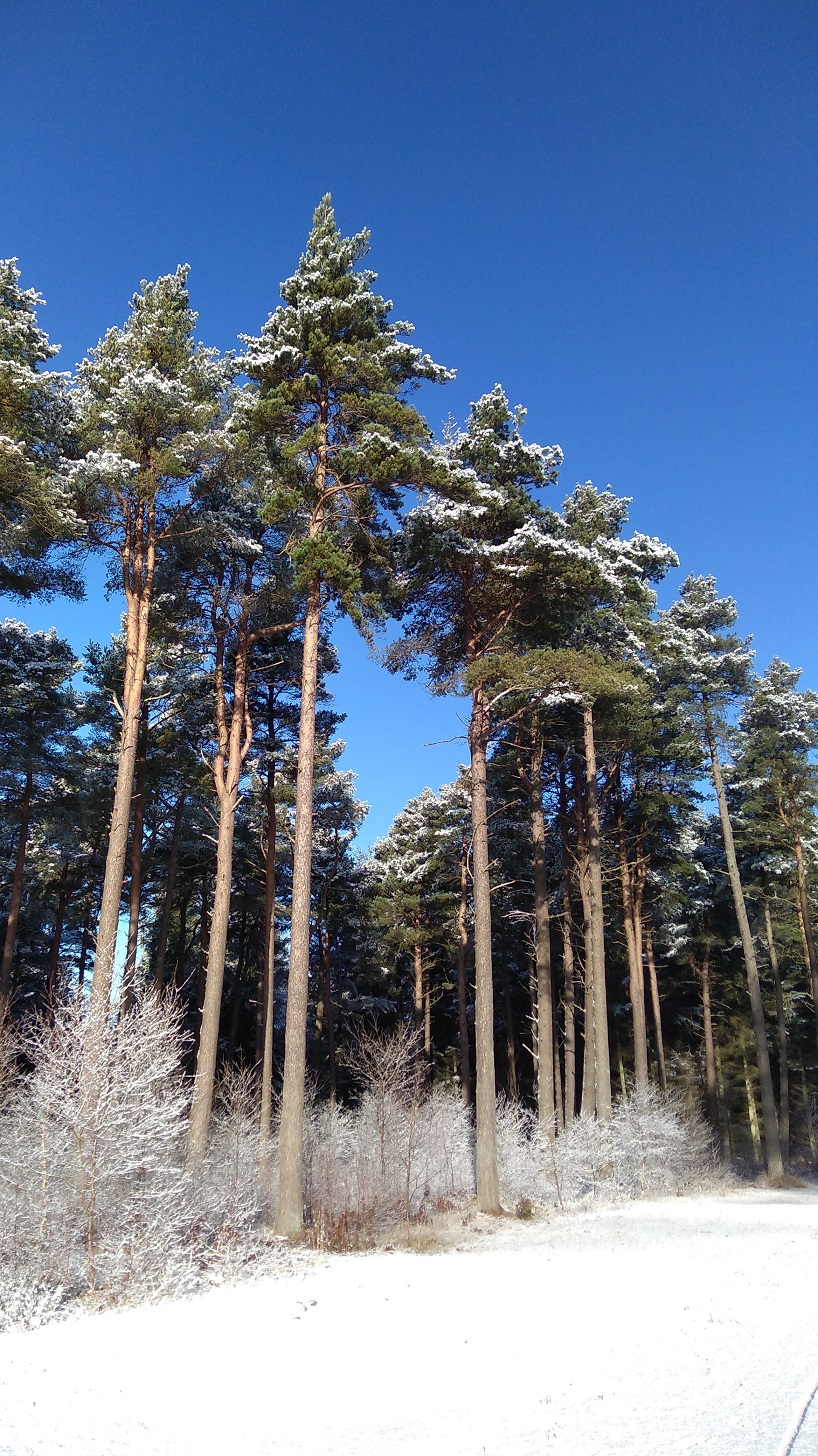
‘There are two species of native conifer tree that produce cones: Scots pine and common juniper. The non-native black pine can also be found in the UK. All of these trees have different shaped pine cones and will hold on to the cones for different lengths of time.’ From The Woodland Trust. The red squirrels love to eat them!

The snow got thicker and there were two sets of dog paws, or maybe another sort of animal trails alongside the man’s now – it must be very interesting to be able to read them properly.
Bracken stalks cracked over from the weight of the snow. Black broom pods showed up starkly against the white.

I had a very quick stop – standing because there was nowhere to sit – for some absolutely delicious, warm jasmine tea. My pack was heavier than normal as I had bought enough food with me to last until Sunday night (two days). All I could think was, oh it is so beautiful!
There were mini pine trees growing between the massive trunks and because they were covered in snow they were lit up and my eye was drawn to them, back and back, layer upon layer of undergrowth where there were tiny, fine branches and twigs. In some places there was no snow, and it looked bright green, marvellous next to the white. As I walked, the snow fell from the trees down the back of my neck while at the same time my feet were tossing up snow which was going down my ankles. Brrr – cold!

I came to some sort of crossroads where there was a man with a bouncy spaniel, ears flying as he enjoyed the snow. I had a happy feeling and a sense of something, a sort of dropping down into my belly and a deep breath, like a much heavier lump, a weight. I was going along a road now, past the Polish Camp Road, and the signs seemed to be going straight on. There were cycles and cars ahead driving past. A woman with two great dogs assured me, yes, I was on the right track.
Beech woods now, a line of them and the smell had changed again, a different woody one. There were straplings, all bronzed and covered by the blanched quilt. Walking on the new snow rather than the slippy, packed stuff, I saw a light ahead like a fairy bower – silver and bright enticing me onwards.
Down a dip I tripped and went over on the same ankle I had sprained slightly in my Argentine Tango class a few nights ago. I felt it ricochet right through my system up to my neck, but thankfully there was no pain as I walked on.

When I came to the Kinshaldy Riding Stables three more horses were being led by a man with a little dog who had an overcoat on. A series of paddocks each had another horse in and children looked as if they were running just for the joy of it.
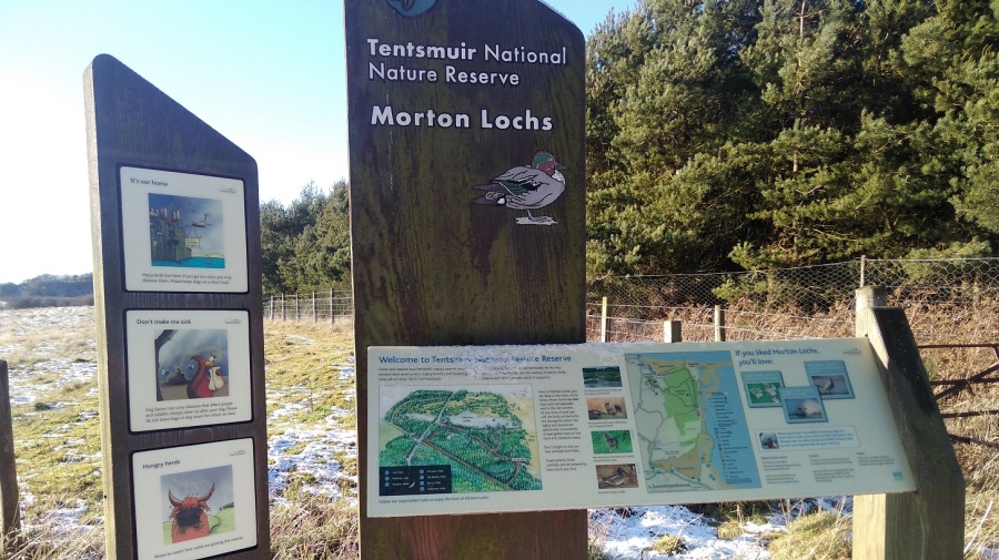
At 10.45am I was at the Tentsmuir National Park Road, the edge of the Nature Reserve. Today I was recording on my phone, experimenting with the idea of a podcast. In fact, unable to splice and mix, I transcribed them later at home. The sound of my heavy breathing on the recordings was off-putting apart from anything else! (It is not as easy as typing notes which can then be cut and pasted into WordPress. Maybe I could find an app which I can speak into which will transform that into the written word?)

Of course the last time I was walking in the snow was in Greece in November where I was looking after horses.
Creak creak went my boots on the snow when suddenly, there was The Crêpe Shack looking most incongruous after miles of nothing but gorgeous natural landscape. It was shut. There was also a playpark and picnic benches, so I sat down to have my elevenses. I was starving!
Traipsing between the dunes with a fuller stomach, I could not find any signs. I was pretty sure that in a few minutes I would see the sea and Kinshaldy beach so simply set off in that direction.

I get so fed up when I have to retrace my tracks, especially as deep snow is such hard work with a rucksack on. The path was not over the sand dunes (as the man with the horses had said), but back through the car park with spaces for coaches and where there are more playparks (so it is obviously very busy in the summer). I wiped away the snow and there was the sign I was looking for – heading back into the forest.
The snow was twice as deep: an inch (2 cms) rather than a half – solid and scrunchy. There was a sky blue as blue could be.
When I had stood up after my snack, I had a dizzy spell which was a first. The whole world span just like my clients described it to me, and the back of my left knee hurt.

The birds were tweet tweeting high up in the pines. Four or five bikes had gone ahead of me, and some people with dogs. When I looked closely at the trees, it didn’t really look like they were covered in icing sugar but with dust, the same way that really thick dust clings to every surface, all the twists and turns of something, like some sort of growth. Some looked like cauliflower heads, white like they say people’s hair sometimes turns overnight from shock.
I was thinking that this must be an old forest because there was no evidence of tree felling. Gradations of vegetation: from the little tufts of grass at the path edges, to the taller ones just behind, then the saplings, which were in front of the medium sized trees, and behind them the absolute giants. All were different textures, some more vertical, others more horizontal, with the vista occasionally broken by waterways.

It was unspeakably beautiful in the brilliant sunshine against the blue sky with no-one around – just amazing.

When I stopped and stood still there were only two sounds: distant waves that could have been traffic; and a sort of moaning, groaning, almost a woolf-type sound, but not at all scary. The latter was very difficult to reproduce and as I stood still it stopped. There were some logs which had been recently cut down in that part – I could smell the newly cut wood.
There were also paths off to the right at intervals, for access to the sea, but most of them were closed for building works.

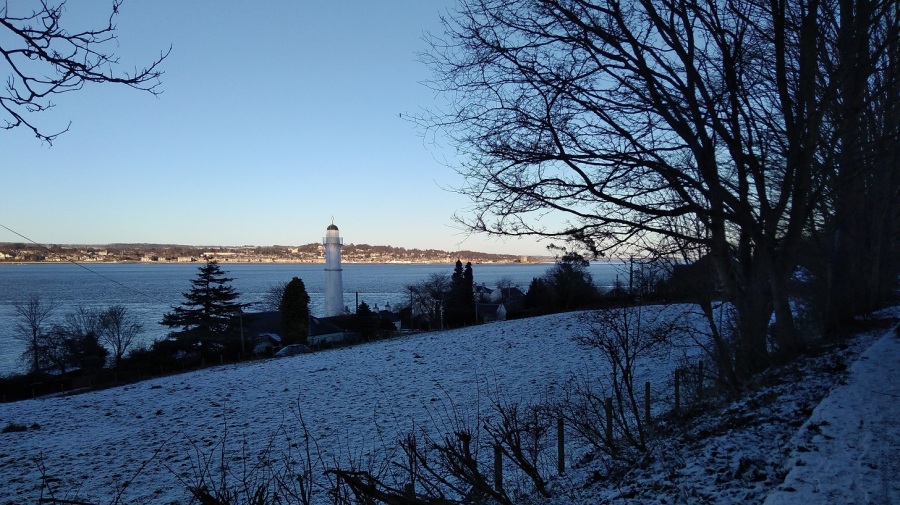
Then wow! Once again I emerged from a long wander through samey landscape, lulled with the regularity of putting one foot in front of another, and suddenly was out of the trees. There was the matching blue water – I had reached Tentsmuir Point at the edge of the promontory where the land turns around the estuary of the River Tay. I stopped to admire the city of Dundee spread out on the opposite bank.

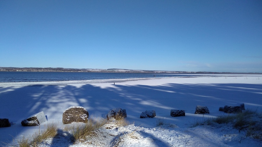
There seemed to be a area of ice where the land met the sea, and a sort of fence going out at right angles into the water. There were very gentle waves. Two gulls as white as the snow were catching the sun nearby, and hundreds more were floating miles away.
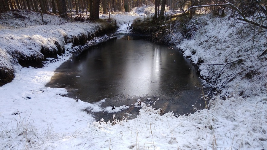
I walked on: a wee pond opaque with ice; thoughts of past love; a train trundling by; and guns sounding. I was at right angles to the point and it was so icy that my pole clattered. I was tired and my feet were aching, although my knee wasn’t. My eyelid did the annoying fluttering thing it used to when I was a teenager. Ploughing on, I heard pee por pee por pee por – thin bird calls, and the almost-sound of snow falling.

There were signs every now and then for the cycle path and forest trails but not for the FCP. A cyclist and women were coming towards me in pairs with hounds. I took a minute’s turn through the heather onto a hillock to get a view of the Tay . It was littered with gulls, and I admired the hills and wind turbines on Tayside. It was almost midday, so more melting was going on.


As I made hand prints in the snow I remembered a TV programme about the Pech Merle in Cabrerets in France perhaps 16,000 to 25,000 BC. Someone recreated them (maybe made by women), and they analysed why people were drawn to make these marks.

It wasn’t easy to locate the signs. Here was Tayport Heath at the edge of the forest and I was coming up to Lundin Bridge – a map helped me to get my bearings. After another tea break I picked up speed, when a sudden lick on my left hand made me look down and there was a young brown greyhound. Bounding beside her mistress was a much older wolfhound with glassy eyes who was more afraid of me than me of him. They were easily overtaking me so I must have been going slowly, what with the rucksack and it being my fifth hour.
As the dogs receded into the distance, they were growling and playfighting. There was a horrible smell of chemical manure.

I found myself at houses and ponds and when I looked at the map I was right in the middle of the forest again. There were no signs and when I asked three men, they confirmed I was a long way away from where I was meant to be. I took a right, following their instructions, and came to a dead end with clear signs saying Private. I went left and the snow got deeper and deeper, my feet plunging down. At a gate I was unsure if I should go through. Away from any sort of path, I was only just able to negotiate and it was really hard going. Swearing away I realised I had done an enormous loop – extra trekking – and as a result I was tired and fed up. It was frustrating to the point of tears.
After my mini drama I spoke to Isobel on the phone by chance which gave me some perspective. I made my way out of the forest and into Tayport, stopping a woman and her bewildered daughter for directions, which were sound. I found a cafe very close to the sea (look left as you approach!) and fell in through the door to the amusement of a couple who wanted to know everything about what I was doing and why. Good question.
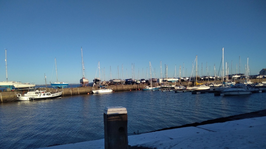
The Harbour Cafe was started 6 years ago as part of Tayport Community Enterprise. It is broadly run by volunteers and is amazing! It is just set back from the bijou working harbour which looked great in the sun when I emerged a while later, refreshed, to continue my walk.
I went along the disused railway line. Right down by the water’s edge, a good way away from me, there was a strip of green where the snow had melted. A row of orangey grasses was punctuated occasionally by a single tree and this strip of sunlit green was absolutely beautiful in the evening sunshine. The bridge was in full view, cars whizzing past and lots of industrial buildings on the opposite side.
I had pain in my right hip – first time for ages – and sore feet. Overall, though, I was feeling much more balanced.

Luckily I am separated from the road by a stone wall. There was a wren looping from fence post to fence post almost letting me catch up with her, causing me to smile. Wren song.
An hour’s walk to Newport, I went under the bridge. Weirdly, there were also signs up to the bridge – I didn’t know why unless it was for the view.

Around a white golden orb that is the sun, almost directly ahead of me most of the time. preparing to sink below the hills which are tapering down into the Tay Firth. A lot of conurbation ahead which could be Newport or Wormit (the end), but I suspected the former. I was trying not to think about the end at this stage other than planning to be in bed for a long period of time when I got there!

‘In 1715 a new pier and inn were built, the work being funded by the Guilds of Dundee which resulted in the settlement being called “New Dundee”. Thomas Telford built a new harbour in the 1820s, and the town expanded and grew into a commuter suburb of Dundee as the prosperous jute manufacturers, industrialists and the middle and upper working class of Dundee established fashionable residences in Newport.’ from Wikipedia
It was very, very beautiful. The water was shimmering and trembling. There was a long line of gold cast by the sun and the completely clear sky was amazing and impossible to capture on my camera.
At 5pm the sun had all but gone down and I was probably 5/10 minutes short of where I should have ended, but it was very nearly dark and I knew a bus was due. I had been checking every stop as I walked through the residential area, all on pavement, amusing myself by looking at the gardens and architecture.

‘Beautiful Railway Bridge of the Silvery Tay! I hope that God will protect all passengers By night and by day, And that no accident will befall them while crossing…’ From The Railway Bridge of the Silvery Tay
‘But when the train came near to Wormit Bay, Boreas he did loud and angry bray, And shook the central girders of the Bridge of Tay On the last Sabbath day of 1879, Which will be remember’d for a very long time.’ From The Tay Bridge Disaster

Aahh – I sat down at last on the 92A bus from Southport Road, near Woodhaven to go back to St Andrews. The bus driver was really sweet: I was the only person on the bus and he explained that although it doesn’t go the bus station anymore, he would take me to the end of the route in the town, wait 3 minutes and then drop me off where I wanted to go.
It was only a short stumble to the hostel where I had booked a bunk a week of so earlier but when I arrived it was unavailable – there was some sort of booking mix-up which he said had happened before. I was more than crest fallen when he explained that I would have to go to Dundee to get a similar priced bunk – St Andrews is an extremely expensive place – but happy that he allowed me to use the facilities and have a hot shower.
I took another bus to Dundee and stayed in the Backpackers Hostel there instead.

Nice photos
LikeLike